Forests Act · Prohibited Area · Trinidad
Mount Hope Estate
Prohibited Area · Forests Act · Trinidad
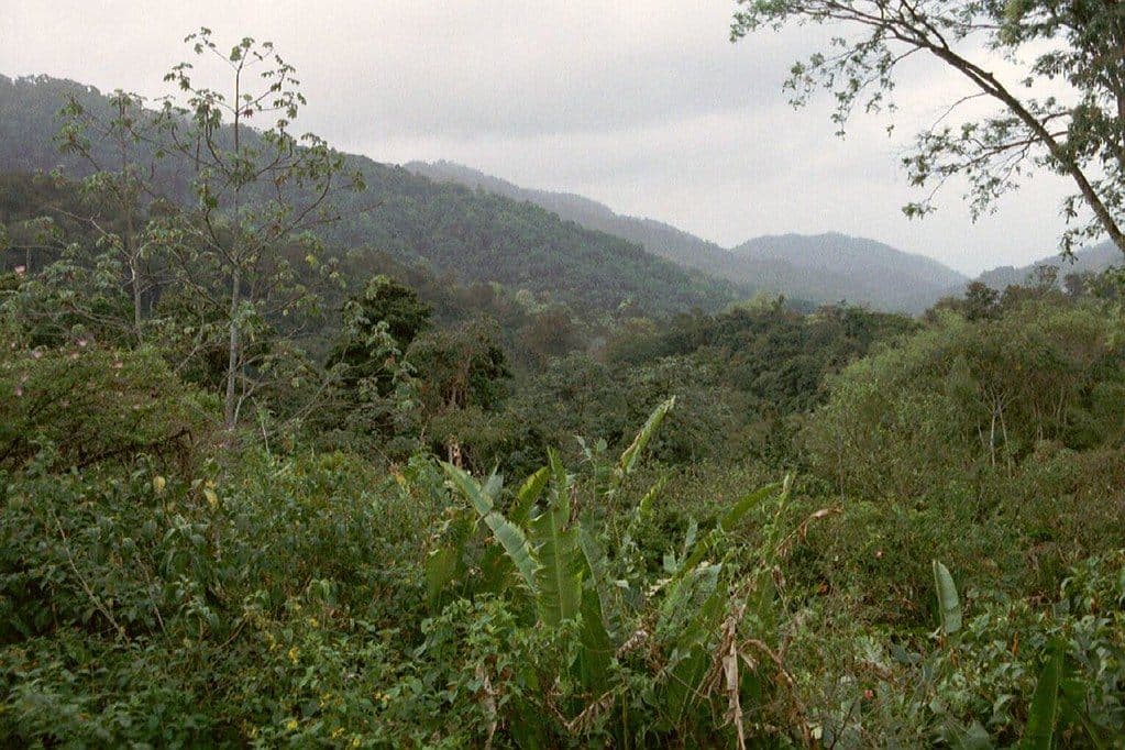
Photo: Rictor Norton & David Allen · Northern Range, Trinidad (CC BY 2.0)
A 209-acre section of the former Mount Hope Estate, situated on the lower forested slopes of Trinidad's Northern Range foothills in the San Juan-Laventille corridor, has been declared a prohibited area under the Forests (Prohibited Areas) Order made pursuant to the Forests Act (Chap. 66:01). The designation places this state land parcel among roughly nineteen prohibited areas in Trinidad and Tobago where unauthorised entry is an offence under the Act, providing a firm legal basis for protecting the vegetation, soils, and watershed functions of a stretch of hillside forest that sits directly above one of the country's most densely populated urban zones.
Mount Hope is a community on the southern foothills of the Northern Range, within the East-West Corridor metropolitan area of northern Trinidad. The estate land itself carries a colonial history: the property appears in the UCL Legacies of British Slavery database under the name 'Mt Hope [Aricagua]', identifying it as a plantation worked by enslaved people during the period of British slavery before Emancipation in 1834. After the collapse of the plantation economy the land reverted progressively to secondary and then to mature seasonal forest, a pattern common to many former estate properties along the Northern Range foothills. By the time the Forests Act prohibited area framework was established in the twentieth century, the forested portion of the estate had become an important fragment of continuous hill-forest linking the urban fringe to the larger Northern Range Forest Reserve above.
The Forests Act (Chap. 66:01) grants the President of Trinidad and Tobago the power to declare, by proclamation, any specified area of a Forest Reserve or state land to be a prohibited area. Entry without written permission from the Conservator of Forests constitutes a criminal offence. For the Mount Hope Estate parcel, the designation serves several overlapping conservation purposes: it shields the remaining seasonal forest from squatting, charcoal burning, and slash-and-burn cultivation; it protects the steep slopes from the gully and sheet erosion that has afflicted many Northern Range foothills where forest cover has been removed; and it safeguards the small stream catchments that contribute to water supply and flood moderation for the corridor communities below. The Forestry Division is the administering authority and may issue entry permits for scientific research and related management activities.
Ecologically, the 209 acres sit within the Trinidad and Tobago Moist Forest ecoregion and support evergreen seasonal and semi-evergreen seasonal forest types typical of the Northern Range lower slopes, grading into more disturbed secondary growth near the forest edge. The Northern Range as a whole is home to more than 430 bird species and over 100 mammal species, with the forested foothills serving as a movement corridor and buffer zone between the highly urbanised valley floor and the higher-elevation primary forest. The principal threats include encroachment from expanding residential development along the East-West Corridor, illegal forest clearing, and the persistent risk of dry-season bushfires recurring across the Northern Range foothills.
Why This Matters
Mount Hope Estate occupies a position of unusual ecological significance for its size: 209 acres of seasonal forest on the lower slopes of the Northern Range, sitting directly above the East-West Corridor, one of the most densely populated urban zones in the country. The forests on these slopes intercept rainfall, slow runoff, stabilise the steep hillsides above urban communities, and feed the small stream catchments that drain into the valley below. In a landscape where almost every other hillside along this corridor has been cleared for residential development, the Mount Hope forest represents one of the last remaining pieces of continuous hill-forest linking the urban fringe to the larger Northern Range Forest Reserve above it.
That connectivity is its most important ecological function. Northern Range wildlife, from birds ranging widely across the foothills to small mammals moving between forest fragments, depends on continuous corridors to maintain gene flow and population viability. Isolated forest patches lose this function over time; connected ones retain it. Mount Hope is part of the buffer zone between the high-elevation primary forest and the developed valley floor, and that buffer role becomes more important as urban expansion continues to claim adjacent hillside land. The forest also stores carbon, moderates local microclimate, and reduces the flood risk that would increase if these slopes were stripped of vegetation.
The land carries a layered history: a colonial plantation worked by enslaved people before Emancipation, then abandoned to forest succession, then formally protected as a Prohibited Area under the Forests Act. What was once cleared and exploited has become a functioning forest reserve. This is what ecological recovery looks like when it is given time and protection. Maintaining that protection against the persistent pressure of urban encroachment along the East-West Corridor is what allows the recovery to continue.
Legal Protections
This area is declared a prohibited area under the Forests Act, Chap. 66:01, or under an Order made pursuant to that Act. Entry, clearing, hunting, and resource extraction within its boundaries without State authorisation is a criminal offence. Penalties include fines and imprisonment. If you witness illegal activity within this area, report it immediately.
Report a ViolationCurrent Threats
- Urban encroachment from expanding residential development along the East-West Corridor
- Illegal clearing and squatting on forested state lands at the urban-forest interface
- Recurrent dry-season bushfire spreading from residential margins into hillside forest
- Gully and sheet erosion on slopes where forest cover is removed
Primary Sources & Legal Citations
- Forests (Prohibited Areas) Order, Chap. 66:01
- Forests Act, Chap. 66:01 · Forest Ordinance Chap. 141 (1916), predecessor legislation establishing the reserve